- Power BI forums
- Updates
- News & Announcements
- Get Help with Power BI
- Desktop
- Service
- Report Server
- Power Query
- Mobile Apps
- Developer
- DAX Commands and Tips
- Custom Visuals Development Discussion
- Health and Life Sciences
- Power BI Spanish forums
- Translated Spanish Desktop
- Power Platform Integration - Better Together!
- Power Platform Integrations (Read-only)
- Power Platform and Dynamics 365 Integrations (Read-only)
- Training and Consulting
- Instructor Led Training
- Dashboard in a Day for Women, by Women
- Galleries
- Community Connections & How-To Videos
- COVID-19 Data Stories Gallery
- Themes Gallery
- Data Stories Gallery
- R Script Showcase
- Webinars and Video Gallery
- Quick Measures Gallery
- 2021 MSBizAppsSummit Gallery
- 2020 MSBizAppsSummit Gallery
- 2019 MSBizAppsSummit Gallery
- Events
- Ideas
- Custom Visuals Ideas
- Issues
- Issues
- Events
- Upcoming Events
- Community Blog
- Power BI Community Blog
- Custom Visuals Community Blog
- Community Support
- Community Accounts & Registration
- Using the Community
- Community Feedback
Register now to learn Fabric in free live sessions led by the best Microsoft experts. From Apr 16 to May 9, in English and Spanish.
- Power BI forums
- Galleries
- Data Stories Gallery
- Fish Oakland County (Michigan)


- Mark as New
- Bookmark
- Subscribe
- Mute
- Subscribe to RSS Feed
- Permalink
- Report Inappropriate Content
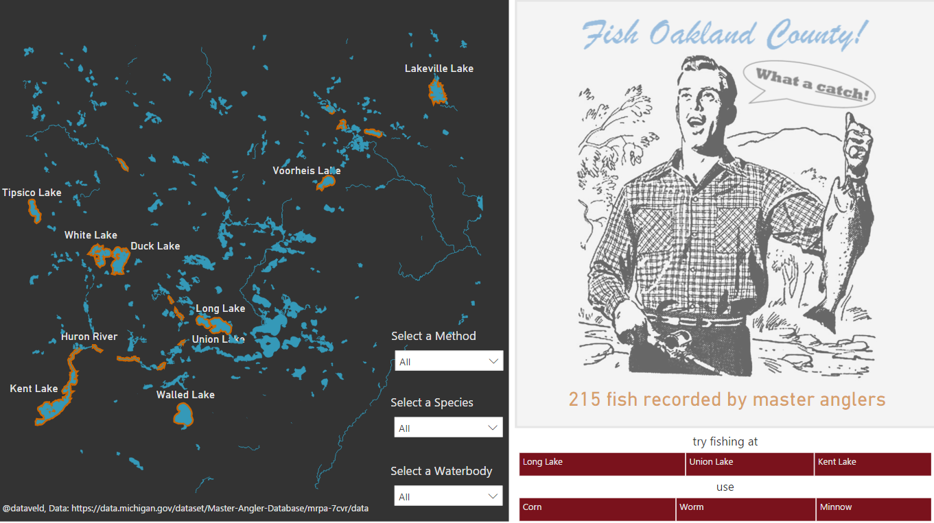
Fish Oakland County (Michigan)
Combines Michigan's master angler database with a map of a local county's water system. Select from a combination of bait, methods, fish species, and water body to determine where you (yes you!) can catch fish too!
By the way, I learned that there are *four* Long Lakes and *two* Duck Lakes in the same county. This is reflected in the map where multiple orange borders appear when you select either of those two lakes.
Data: Master Angler Database from data.michigan.gov
Original shapefile: Access Oakland (Oakland County open data)
eyJrIjoiOWQzNmUwYzAtMTkyYi00NjI5LTlkYTYtZjExMTQ1NjUxNmM4IiwidCI6IjRlZmE3NzhmLTVmNmMtNDAxZS04OGFmLWNmMTliZDA5ZDE0OCIsImMiOjN9
- Mark as New
- Bookmark
- Subscribe
- Mute
- Subscribe to RSS Feed
- Permalink
- Report Inappropriate Content
Hi Loved your report. I had a question in your map visual. I was wondering how could you highlight the locations based on slicer selections.